This video from ABC News: Tracking Animals With GPS from the year 2000 takes us back to the early days of CyberTracker. At that time, we had one CyberTracker running on an Apple Newton unit in the Karoo National Park in South Africa and just started our second project with the Kwe San Bushmen in Namibia, using the PalmPilot.
Tag Archives: CyberTracker
Citizen science: creating an inclusive, global network for conservation
Technology is allowing anyone to contribute to scientific research, with implications for conservation, disease prevention and much more.
Emerging Technologies: Smarter ways to fight wildlife crime
UNEP Global Environmental Alert Services
Photo: CyberTracker workshop organised by the African Wildlife Foundation
The illegal trade of animals – for luxury goods, traditional medicine or cultural ceremonies, pets, entertainment, and even research – is a major threat to wildlife conservation and welfare (Baker et al., 2013). Poachers and illegal traders use highly sophisticated and rapidly changing techniques to avoid detection. To keep pace with the “war on wildlife”, conservation and law enforcement communities have started to adopt cutting-edge military tools and techniques. High-tech equipment can magnify counter-poaching efforts without requiring armies of rangers or risking lives. Tools include acoustic traps, mobile technology, mikrokopters, radio frequency identification tags, encrypted data digital networks, camera traps, DNA testing, radio collars, metal scanners, and satellite imagery.
Celebrating 20 Years of Tracker Evaluations!
To celebrate 20 years of CyberTracker Tracker Evaluations, initiated in 1994, we organised a CyberTracker meeting where evaluators were able to engage in critical discussion and peer review. Peer review is essential to maintain standards, especially as the network of CyberTracker evaluators continue to grow. Only by testing each other and engaging in critical discussion of evaluation principles, protocols and the interpretation of tracks & signs in the field is it possible to ensure that we all maintain the same standards.
We also discussed the creation of The Tracker Association, which will be based in South Africa, but will be open to all trackers worldwide. In addition to qualified trackers, who will be full members, we will also welcome any tracker who is working towards becoming a qualified tracker. While CyberTracker Conservation is a Public Benefit Organisation whose mission includes maintaining tracker standards through tracker certificates, CyberTracker is not a membership-based organisation. We therefore need a membership-based Tracker Association which can represent and promote the interests of trackers.
It was also great to simply have everyone together around a camp fire, relaxing and telling stories. Shani Preller suggested that the Tracker Association logo should be a camp fire, representing the tracker community. The art of tracking and the making of fire are perhaps the most ancient human traditions.
We are planning to make this an annual event, something that will help to strengthen and grow CyberTracker evaluations into the future.
The CyberTracker meeting was attended by Wilson Masia, Juan Pinto, Adriaan Louw, Lucas Mathonsi, Alan Yeowart, Lee Gutteridge, Mark Stavrakis, Taryn Ingram-Gillson, Shani Preller, Deirdre Opie, Kersey Lawrence, James Steyn and Louis Liebenberg.
CyberTracker used in Research on Endangered Bottlenose Dolphin of New Zealand
Sarah Dwyer, Gabriela Tezanos-Pinto, Ingrid Visser, Matthew Pawley, Anna Meissner, Jo Berghan and Karen Stockin have just published a paper on “Overlooking a potential hotspot at Great Barrier Island for the nationally endangered bottlenose dolphin of New Zealand” in the journal Endangered Species Research, Vol. 25:97-114, 2014.
ABSTRACT: Conservation initiatives are typically constrained by economic circumstances, a factor certainly true for marine mammal conservation in New Zealand. Most research in this field has been conducted following concerns over anthropogenic impacts on populations and has therefore been funded and/or driven by stakeholder interest. Bottlenose dolphins Tursiops truncatus are classified as ‘Nationally Endangered’ in New Zealand waters. Here, we present the first study on occurrence, site fidelity and abundance of this species off Great Barrier Island (GBI), a previously overlooked region within the home range of the North Island population. Dedicated boat-based photo-identification surveys were conducted monthly from 2011−2013, resulting in 1412 sighting records of 154 individuals. Dolphins were recorded during all months of the year, with a higher probability of encounter in deeper waters during summer and shallower waters during winter and spring. Group sizes (median = 35, mean = 36) were higher than previously reported for this population in other regions. Individual re-sighting patterns were variable; however, overall site fidelity was high (mean monthly sighting rate = 0.33). A Robust Design approach resulted in seasonal fluctuations in abundance and temporary emigration. Based on a super-population estimate, 171 dolphins (CI = 162−180) visited the area during 2011−2013. Our data suggest that GBI is a potential hotspot for bottlenose dolphins of the North Island population rather than a corridor to reach other destinations. We highlight the need for researchers, managers and funding agencies to consider the entire range of a population when conducting or funding research.
The Value of Animal Tracking Skills
After generations of fading into obsolescence, wildlife tracking has grown in popularity in recent years. No doubt this is due to the work of evolutionary biologist, Louis Liebenberg. He recognized the value of animal tracking skills, and helped traditional African hunter-gatherers use them to earn a living in data collection for wildlife monitoring, research, and anti-poaching efforts.
Part of Liebenberg’s work involved development of the CyberTracker evaluation system, which became an international standard for tracking skills. This elevated the ancient art and science of tracking to a respected discipline within the modern world. But regardless of its status within the modern world, tracking is useful to almost anyone.
Tracking skills deepen your awareness and understanding of wildlife. And that can help you better protect pets, livestock and garden produce; develop competency in hunting; make more informed decisions that impact wildlife; and meet people from vastly different walks of life. Not to mention the fact that it’s great physical and mental exercise, all at once.
Using Cyber Tracking Technology to Outsmart Poachers
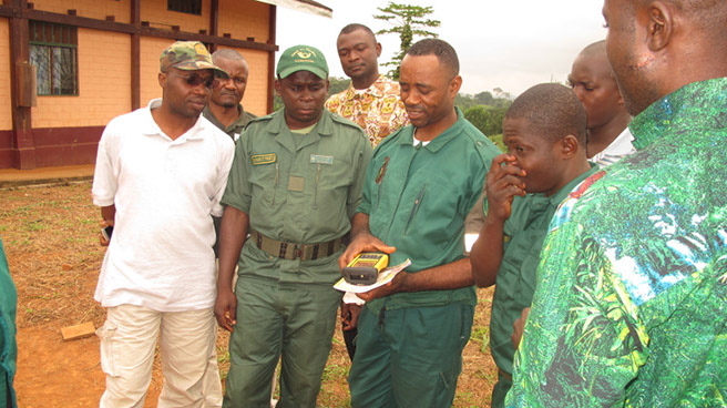
I’m just recently back in Lomie (on border of the Dja Faunal Reserve in Cameroon) from two days of practical training for rangers on the use of the CyberTracker/Trimble for ecological monitoring and anti-poaching.
Instead of counting living monkeys, elephants, and great apes, we witnessed the arrest of about 15 poachers on more than five different occasions. We have been hiding and running, sleeping on the ground next to the fire with guards at both sides of our overnight spot— switching every two hours, assuring security. The Conservator, Achile Mengamenya, who was with us, has a good and dedicated team of park wardens (we were about 20). Nobody complains, while equipment is lacking, and everybody works hard. We were fed water and some rice and tomato sauce in the evening, and in the morning we have one or two beignets for each.
The total amount of confiscated illegal wildlife, from the poachers, is surprising—sitatunga, forest duikers, living and dead pangolin, several species of monkey, freshly killed or smoked. No chimp, gorilla or elephant meat though…as these species are victim of a different type and more specialized category of hunters.
We heard only one group of chimps was heard about 1 km from our campsite, so we can consider that this periphery of this Natural World Heritage site is probably almost hunted out.
However, based on the interrogations of the arrested poachers, and witnesses of some park guards, it is clear that the Dja is still housing good numbers of all species, and remains attractive for a lot of people who prefer to put snares in the park instead of working on their fields in the village. With the Dja managers lacking any support for the last few years, and no control happening anymore, the Dja Biosphere is being hit very hard. And poachers are getting increasingly aggressive. Over the last few weeks, one guard got shot in his arm, another received a blow of a machete above his eye, and last night inhabitants of Lomie attacked the post of the Conservator and his team.
Alain Lushimba (who is here with me, taking the lead in the training on cybertracker) and myself agree on the area’s high resemblance with the Lomako Yokokala Faunal Reserve. While being a beautiful forest with high potentials for biodiversity, the Dja is probably in the same conditions today as the Lomako forest was in 2004 when AWF started working in DRC. Support is needed. “Performance Based Management” and “Evidence-based Conservation” à la Lomako, and the lessons learned, will prove most helpful here. The park authorities and their team are extremely happy with the support we are giving.
Today, we will adapt a work plan in order to respond, first of all, to the absolute priority to get those poachers out of the Reserve, restore law and order, and let the people know that the conservator and his team are operational again.
All paths will be georeferenced, poaching camps destroyed, traces of gorillas, chimps, elephants, bongo and buffaloes recorded, and groups of monkeys—now all frightened—counted. Data will be shared with AWF headquarters the AWF-GIS (mapping) Centre. Evaluation on the ground is planned about 4 to 5months from now.
About the Author
Jef Dupain is AWF’s Director, African Apes Initiative. He holds degrees in biology and zoology from the University of Antwerp, has served as an associate professor for great ape conservation at Kyoto University, and has nearly 20 years of practical experience working on great ape conservation in and out of the field—he has an esteemed reputation as an authority on great ape conservation in Africa.
Using technology in the fight against rhino poaching
Controlling rhino poaching with the country’s eyes on you is just one of the many tasks that fall under managing the massive area that is the Kruger National Park (KNP). With nearly 2-million hectares of diverse flora and fauna to keep track of, and only about 300 field rangers to do so, monitoring the park is a logistical nightmare. However, the use of innovative technology and customised open-source software is making the ongoing conservation of South Africa’s natural heritage possible. The Kruger National Park is divided into 22 sections, each managed by one section ranger with a number of field rangers to patrol each section every day. Field rangers are imperative for conservation – from the ground, they contribute directly to the management of the park by collecting basic environmental data during their daily patrols. Information such as the distribution of rare and endangered species, availability of surface water and disease outbreaks are integral in the ongoing management of the park. These indicators are used by the SANParks management to provide an early warning system for disease outbreaks, identify trends in illegal exit and entry points, and enable the detection and control of invasive alien species. Therefore, it is extremely important that the data collected is accurate, but when information is recorded manually it is almost impossible to ensure its complete accuracy, which makes collating and using the raw data for decision-making difficult.
When faced with the unique set of challenges that the Kruger National Park presents in terms of ecological conservation, Douw Swanepoel, a Section Ranger of the Kruger National Park, recognised the value of the CyberTracker system in 2000 and soon afterwards 44 GPS devices were purchased for the park. CyberTracker is an open-sourced programme developed by Louis Liebenberg who felt that there was a need for a tracking programme that could work from a palmtop device. The programme is freely available, and the Kruger National Park team has customised the programme specifically for the park’s needs with databases including ranger patrols, vegetation condition assessments, animal behaviour monitoring and invasive species distribution mapping.
The CyberTracker programme used on the Trimble device form a solid partnership, producing a piece of equipment designed specifically to assist with conservation in the park. With an icon-based interface and descriptions in both English and local language, the CyberTracker system is easily accessible to field rangers regardless of literacy. Information is recorded with latitude and longitude coordinates through the integrated GPS system, ensuring that separate GPS skills are not necessary, and as data is captured electronically using graphic check lists, inaccuracy is reduced and minimal training is needed before the rangers can begin recording data. Moving map functionality allows the ranger to pinpoint his exact location on a 1:50 000 or 1:250 000 topographical map or aerial photograph should a ranger urgently need assistance from the SANParks office. With a built-in camera, rangers can document and geotag exactly what they see and send the photo immediately from the field to the office for review, increasing field to office collaboration.
“The device assists the field ranger to accurately call for assistance once a suspicious spoor or even a poached rhino is found,” says Louis Lemmer, from the SAN Parks Honorary Rangers’ National Executive Committee when asked how the device is helping in the fight against rhino poaching. “Previously they had to rely on their general knowledge and geographical features when calling for help, often leading to slow response times due to possible inaccuracies and confusion. The use of GPS technology removes this. Furthermore it is now possible to track and accurately map poacher movements. In this way patterns can be established and plotted on maps. This helps to plan preventative operations.”
The devices are useful as part of a long-term solution because at the end of each day, the data that the field ranger has collected is downloaded on to the section ranger’s computer and then uploaded to SANParks’ GIS/RS Analyst, Sandra Mac Fayden. This allows her to create a full, sophisticated picture of the environmental state of the Kruger National Park with intricate detailing that can only be sourced by professional field rangers with a working knowledge of the area. Once the data has been downloaded it is archived and documented so that it is usable in the long-term.
Thresholds in the programme are set so that the limits of acceptable change in the environment can be monitored. The data in the database is then used in routine analyses run through the programme in order to assess whether there is any danger of ecological factors exceeding those thresholds, thereby warning park management of any unacceptable changes. For example, monitoring data is analysed for each river which flows through the Kruger National Park and should water levels lower and exceed the threshold set by park management, urgent action is required.
With something as volatile and ever-changing as ecology, correct data is essential in its efficient management. In the fight against rhino poaching in the Kruger National Park where intervention and constant vigilance is necessary, rapid decision making is critical and this is only possible when every step of the data collection and analysis is accurate. By using the irreplaceable knowledge and ability of field rangers, curbing human error through easy-to-use software and technology with GPS capabilities, the SANParks team is efficiently managing the vast and diverse ecosystem of the Kruger National Park and engaging in the ongoing fight against rhino poaching.
Timbavati now home to one of only four Master Trackers in South Africa
South Africa – Have you ever thought about the skill it takes (not to mention the guts) to be able to track animals of the wild? We’re talking lions, leopards and pretty much every other animal you can think of.
Lucas Mathonsi from Sgagula, South Africa knows what we’re taking about because he is now one of only four coveted Master Trackers in the world.
Where the story begins:
His story begins as a five-year-old boy who used to accompany his father who was a ranger in the Timbavati reserve. It is here that Lucas Mathonsi was taught about the animals in the reserve and how to track them.
Over the next 47 years, Lucas honed his skills working as a tracker in the Timbavati and Balule reserves, before joining Lion Sands in 2006 as a Senior Tracker. Lucas is renowned for his particular penchant for tracking the elusive Leopard.
The story now:
In 2013, under the tutelage and mentorships of Louis Liebenberg, Juan Pinto and Wilson Masia, Lucas achieved the much coveted Master Tracker qualification, becoming one of four existing Master Trackers in the world, and only the second tracker to be awarded this prestigious qualification in the Lowveld since 1994.
What it takes to be a qualified tracker:
The Cybertracker qualification is an assessment that was created by Louis Liebenberg after realising that the art of tracking is a skill and talent that needs to be recognised and validated. An assessment system has been created and revolves around the identification of tracks as well as following animal tracks and trails in order to find the animal. For detailed info, click here.
With hard work comes great reward:
In celebration of this remarkable life achievement, the Lion Sands Game Reserve will be naming the link road between Lion Sands Sabi Sand and Lion Sands Kruger National Park the “The Mathonsi Link”.
BACKWARD COMPATIBLE
CyberTracker fuses ancient knowledge with cutting-edge technology
By Nancy Bazilchuk
July 2008, Conservation Magazine
In 2003, trained trackers combing the rich jungles in the Republic of Congo’s Lossi Sanctuary for gorillas and chimpanzees stumbled upon a disturbing trend. Duikers, dog-sized antelopes that weave and dive through the jungle’s dense undergrowth, were dying at an astounding rate—local indices dropped 50 percent compared to a 2000 census. Gorillas and chimpanzees were dying at similar rates. Blood tests confirmed the culprit was the deadly virus Ebola. The surprise was that no one had previously known that Ebola killed antelopes.
Yet there was no doubt the terrible data were real. The findings were based on hundreds of observations precisely mapped with CyberTracker software. CyberTracker allows hand-held computers to use stylized images instead of text for data entry. Its heart is a menu of icons that depict whatever elements researchers choose. Trackers need only select a pre-programmed image that matches what they see—a grazing antelope, a carabid beetle—and with one tap, the observation is recorded and paired with geographic coordinates via a Global Positioning System (GPS) link. Trackers hardly have to break stride as they work, which allows enormous numbers of data points to be amassed with little effort. The information can be downloaded to a computer and immediately mapped, thus enabling scientists to make real-time observations about trends, such as the ones from Lossi Sanctuary that showed duiker declines.
The program’s greatest strength, and the feature that sets it apart from its competitors, is its ability to transcend language and culture because of its reliance on images, not words, for data entry.
CyberTracker creator Louis Liebenberg, a South African scientist and author, first came up with the idea in 1996 while tracking with a group of Kalahari Bushmen. Liebenberg realized that he could help save the Bushmen’s rapidly disappearing knowledge if he could find a way to help trackers, who could neither read nor write, record their observations. Thus CyberTracker was born.
CyberTracker’s biggest impact has been in South Africa’s national park system. Kruger National Park official Judith Kruger says that rangers use 110 hand-held computers daily to record sightings on patrol—everything from broken fences to elephant-damaged trees to invertebrates. Liebenberg and two rangers from South Africa’s Karoo National Park used it to document seasonal shifts in black rhino feeding behavior. And CyberTracker is being used to record garbage found littering beaches in Gabon as a way to persuade source nations to help clean up. The program allows for remarkable precision: one 500-m-long section of shoreline in Loango National Park was covered with 535 plastic water bottles and 560 flip-flops among more than 3,000 bits of trash.
The software is free and has been downloaded by more than 6,000 people since it was first made available on the Internet in 2000. About 500 users from 30 countries have registered the software—from the entire Spanish National Park Service to a multinational research group in the Arctic to individual trackers in the U.S. With the help of a 2-million-Euro (approximately US$2 million) grant from the European Commission and Conservation International, Liebenberg is developing the next generation of Cyber-Tracker. Three versions will offer increasingly complex programming features along with conservation-specific analysis tools to allow the calculation of standard measures such as Patrol Effort or Index of Abundance.
Liebenberg says the biggest benefit has been to give an authoritative, scientific “voice” to skilled trackers in Africa who can’t otherwise share their knowledge because they can’t write. Karel Benadie is a ranger and expert rhino tracker who worked with Lieben-berg in Karoo National Park. He told Liebenberg that his inability to write down his rhino observations meant “the PhDs would never listen to him before,” Liebenberg said. With Cyber-Tracker, “Now they do.”
More on the Tracker: www.cybertracker.co.za
Liebenberg, L. et al. 1999. Rhino tracking with the CyberTracker field computer. Pachyderm 27:59-61.
Leroy, E. et al. 2004. Multiple Ebola virus transmission events and rapid decline of Central African wildlife. Science 303:387-390.
About the Author
Nancy Bazilchuk is a freelance writer based in Trondheim, Norway.